
Google Maps Lands Tourists
Google Maps-In an unexpected turn of events, a group of tourists from Hyderabad found themselves in a precarious situation when their reliance on Google Maps led them into a waterlogged stream near Kuruppanthara in Kottayam district, Kerala. This incident occurred late on a rainy Friday night and has highlighted the potential risks associated with digital navigation tools, especially in unfamiliar and flood-prone areas.
Google Maps-The Incident
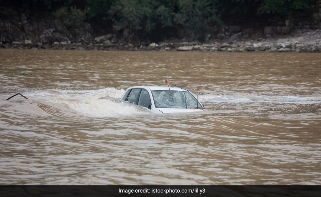
Google Maps-The group, consisting of four members including a woman, was on their way to Alappuzha, a popular tourist destination in Kerala known for its picturesque backwaters and houseboat cruises. Due to the heavy rains that had been lashing the region, many roads were submerged under water. Unfamiliar with the local geography and relying solely on Google Maps for directions, the tourists inadvertently drove into a stream that had overflowed its banks.
Google Maps-Navigational Error
Google Maps-According to the police, the incident was a direct result of the tourists following the route suggested by Google Maps without realizing that the path ahead was unsafe due to the heavy rains. The digital map did not account for the road being flooded, leading the car directly into the swollen stream. The water quickly engulfed the vehicle, but fortunately, all passengers were able to escape before the situation became dire.
Google Maps-Immediate Response and Rescue
Local authorities and residents responded promptly to the incident. Hearing the commotion and seeing the stranded tourists, locals rushed to their aid, managing to rescue all four passengers from the sinking car. The quick response of the community and the efficiency of the rescue operation were crucial in ensuring that there were no casualties or serious injuries.
The Role of Technology in Navigation
Dependence on Digital Maps
The incident has sparked a conversation about the heavy reliance on digital maps and navigation systems like Google Maps. While these tools have revolutionized travel by making it easier to navigate unfamiliar places, they are not infallible. Maps can sometimes be outdated or fail to reflect real-time conditions, such as road closures, construction work, or in this case, natural calamities like flooding.
Limitations of Digital Navigation
Google Maps and other navigation apps typically use algorithms that prioritize the shortest or fastest routes, but they may not always consider the safest paths, especially in adverse weather conditions. In rural or less-developed areas, the data might not be as accurate or up-to-date, leading to potential mishaps. This incident serves as a reminder that while technology can be a great aid, it should be used in conjunction with local knowledge and real-time information.
Impact on Tourists and Local Community
Shock and Relief
For the tourists from Hyderabad, the experience was undoubtedly harrowing. What was supposed to be a leisurely journey through one of Kerala’s most scenic routes turned into a night of distress and panic. The quick rescue was a source of immense relief, but the incident has left them more cautious about relying solely on digital tools for navigation.
Community Spirit
The local community’s response to the incident has been commendable. Residents near Kuruppanthara displayed remarkable solidarity and readiness to help, showcasing the strong community spirit that is often seen in times of crisis. Their swift action not only saved the tourists but also highlighted the importance of human intervention in emergencies.
Broader Implications and Safety Measures
Rethinking Navigation
This incident is a wake-up call for both users and developers of digital navigation tools. For users, it underscores the importance of being aware of their surroundings and not blindly following digital directions, especially in unfamiliar or potentially hazardous conditions. Cross-referencing with local advice, using multiple sources of information, and being cautious in adverse weather can prevent such mishaps.
Enhancing Digital Tools
For developers, this highlights the need for enhancing the accuracy and reliability of navigation apps. Integrating real-time data on weather conditions, road closures, and other hazards could improve the safety of users. Collaborations with local authorities to update maps more frequently and incorporate warnings about flood-prone or dangerous areas could also be beneficial.
Local Authorities’ Role
Local authorities can play a significant role by ensuring that digital map providers have access to the latest information on road conditions. Setting up warning systems that alert drivers to potential dangers ahead and improving signage in vulnerable areas can also help prevent similar incidents in the future.
Conclusion
The incident in Kottayam, where tourists from Hyderabad were led into a flooded stream by Google Maps, serves as a stark reminder of the limitations of digital navigation tools. While technology has made traveling more convenient, it is not a substitute for local knowledge and situational awareness. This event highlights the importance of using digital maps judiciously and being prepared for unforeseen circumstances, especially in unfamiliar territories.
The quick rescue by local residents also underscores the importance of community readiness and the human element in crisis situations. Moving forward, both users and developers of navigation tools must take steps to ensure safer travel experiences, integrating technology with real-time data and local insights to prevent such incidents.